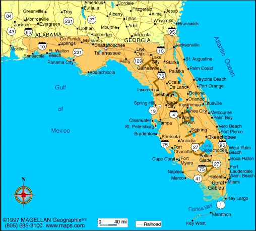
Jacksonville (Florida) - geography.
Publié le 27/05/2013

Extrait du document


«
Jacksonville is a center for business, manufacturing, finance, insurance, culture, and medicine in northeastern Florida and nearby Georgia.
It is also a major deepwater portof entry that has long been the home of important United States Navy facilities, including the Mayport Naval Station and the Jacksonville Naval Air Station.
The IntracoastalWaterway passes through the city.
Jacksonville is Florida’s most industrialized city.
Drawing on the raw materials produced by the region’s farms, forests, and mines, manufacturers produce chemicals, pulpand paper products, fabricated metal products, paints, plastics, machine parts, and processed foods.
Tourism is also important to the local economy.
Large office complexeshave been built in downtown Jacksonville and at a number of outlying sites along interstates 295 and 95, particularly in the Butler Boulevard area in southern Jacksonville.
Jacksonville is well connected to the rest of its metropolitan region by Interstate 95 (the main north-south axis of urban development) and Interstate 10 (which originates inJacksonville and connects the city to Florida’s panhandle); Interstate 295 bypasses the densest areas of Jacksonville to the west, linking the city’s northern and southernsections and avoiding the downtown bottleneck where Interstate 95 crosses the Saint Johns River at the Fuller Warren Bridge.
In addition to being a regional highway crossroads, the city is a railway hub, with Amtrak passenger service and several freight routes.
The city’s expanding airport, locatedin northern Jacksonville, was the nation’s fastest growing in passenger volume in the mid-1990s.
V GOVERNMENT
Jacksonville has a mayor-council form of municipal government.
The mayor and the 19 councilors are elected to four-year terms.
VI HISTORY
The Timucua people resided in the Jacksonville region for centuries before Europeans first arrived in 1562, led by French explorer Jean Ribault.
The Europeans carrieddiseases to the Timucuans, who lacked immunity and were quickly decimated.
In 1564 the first white settlement in the area of modern Jacksonville was established byFrench Huguenots (the name given the French followers of Protestantism).
They built Fort Caroline on a bluff above the Saint Johns River.
In 1565 troops from the Spanishsettlement of San Agustín (now Saint Augustine) attacked the fort and killed its defenders.
Meanwhile, French troops sailing to attack San Agustín were shipwrecked by astorm and later massacred by the Spanish.
While the French destroyed Fort Caroline in a battle three years later, they never again attempted settlement in Florida.
TheBritish took control of the area from Spain under a treaty ending the French and Indian War (1754-1763).
Jacksonville grew up around a ford, or shallow place, in the Saint Johns River.
Because settlers drove cattle across the river there, the community was first known asCowford.
In 1822 (the year after the Florida territory came under United States control) a more formal community was laid out and named for the new governor, AndrewJackson.
Jacksonville was chartered as a town in 1832 and incorporated as a city in 1859.
By the mid-19th century, it had become an important port for the timber, cotton,and citrus fruits that were produced in the city’s growing hinterland.
During the American Civil War (1861-1865), Jacksonville was occupied by Union troops on fourseparate occasions, and much of the city was destroyed by the end of that war.
By the 1880s Jacksonville was attracting a growing number of winter vacationers, which prompted the completion of the first railroad line from the North.
Once this linebegan operating, Jacksonville immediately became a vacation mecca (nicknamed “The Winter City in the Summer Land”), luring more than 100,000 visitors per year.
In thesame era, however, a yellow fever epidemic in 1888 killed hundreds of inhabitants and a disastrous fire in 1901 destroyed the city again only 40 years after the Civil War.But Jacksonville quickly rebuilt itself and continued to grow and prosper.
During World War II (1939-1945) the United States government constructed military installations in the area, including the Mayport naval facility, which became one of theUnited States Navy’s most important bases in the Southeast.
Following the war, Jacksonville decentralized as a result of population movement to the suburbs.
The CivilRights Movement produced upheaval in the city during the 1950s and 1960s because Jacksonville at the time was one of the South’s leading bastions of racial segregation;associated rioting broke out in 1966.
The crusade to produce social change led to effective school desegregation and urban renewal programs.
Also helping to launch thenew era was the 1968 consolidation with Duval County, still regarded as one of the most ambitious metropolitan government experiments undertaken in America.
By the 1970s and 1980s, Jacksonville had become part of the Sun Belt development thrust that was transforming many of the nation’s southern-tier states.
Expansion ofexisting industries together with the creation of a thriving new service sector drew thousands of job-seeking migrants to the area.
The new business community successfullytransformed the city’s image, one of its greatest successes being the attraction of the Mayo Clinic’s first satellite facility outside its home base in Rochester, Minnesota.During this period the city oversaw the cleanup of emissions from its paper and chemical manufacturing plants.
In the 1990s the successful luring of a major league footballfranchise galvanized the city.
Contributed By:Peter O.
MullerMicrosoft ® Encarta ® 2009. © 1993-2008 Microsoft Corporation.
All rights reserved..
»
↓↓↓ APERÇU DU DOCUMENT ↓↓↓
Liens utiles
- Jacksonville (Florida) - geography.
- Miami (Florida) - geography.
- Miami (Florida) - geography.
- Art Deco I INTRODUCTION Art Deco Historic District The Art Deco Historic District is located at the southern end of Miami Beach, Florida.
- Florida - Facts and Figures.


