Devoir de Philosophie

Map - geography.

Publié le 26/05/2013

Extrait du document

Map - geography. I INTRODUCTION Early Map of Eastern Europe Early maps often served several purposes. They provided topographical details about a country as well as information about the area in relation to the navigator's country. This map from about 1600 depicts the maritime commerce of Barcelona, Spain, with the Near East and the area around the Black Sea. SEF/Art Resource, NY - geography. Map, representation of a geographic area, usually a portion of the earth's surface, drawn or printed on a flat surface. In most instances a map is a diagrammatic rather than a pictorial representation of the terrain; it usually contains a number of generally accepted symbols, which indicate the various natural, artificial, or cultural, features of the area it covers. II TYPES OF MAPS Terrestrial Globe © Microsoft Corporation. All Rights Reserved. Maps may be used for a variety of purposes, and as a result a number of specialized types of maps have been developed. A Topographic Maps Topographic Map In addition to showing general locations and political boundaries, topographic maps depict the geology and special features of an area. This type of map offers many advantages. For instance, most backpackers use topographic maps to navigate through wilderness, planning their routes with obstacles and landmarks in mind. If they should get lost, they can find their bearings again by aligning their map and compass to a prominent feature observed nearby. A key on each map indicates the distance scales and special symbols (for features such as railroads, schools, airstrips and water towers) used to create it. Generally, the green on a topographic map indicates forest or vegetation, while the white areas indicate areas that are bare of growth. Series of brown lines indicate mountains and hills, showing elevation and relative steepness. Each line represents a specific unit of elevation; where the lines are very close together, the terrain is quite steep. © Microsoft Corporation. All Rights Reserved. The basic type of map used to represent land areas is the topographic map. Such maps show the natural features of the area covered as well as certain artificial features, known as cultural features. Political boundaries, such as the limits of towns, countries, and states, are also shown. Because of the great variety of information included on them, topographic maps are most often used as general reference maps. B Special-Purpose, or Thematic, Maps Relief Map Relief maps are three-dimensional models of the terrain in an area; on them, color and scale are used to indicate geographical features rather than simply to delineate political boundaries. Because of this feature, relief maps are extensively used in engineering and the military. This map shows portions of Alaska and northwestern Canada. United States Geological Survey Among the most important of the special-purpose maps are hydrographic and aviation charts. Hydrographic charts are used for the navigation of ships and cover the surface of the oceans and other large bodies of water and their shores. Over the water portion of a chart, depths are shown at frequent intervals by printing the number of fathoms of water at low tide. Shoal areas are circled or shaded to give them greater visibility, and the limits of channels are shown by lines. The type of bottom, such as sand, mud, or rock, is also indicated. An important feature of such charts is the exact location of lighthouses, buoys, and other aids to navigation. The only other shore features shown on a chart are such landmarks as tall buildings or prominent peaks on which a navigator may wish to take a bearing. Aviation charts for use over land somewhat resemble topographic maps but bear in addition the location of radio beacons, airways, and the areas covered by the beams of radio range stations. Taking a Bearing In navigation, the direction of one object from another is called a bearing. To take a bearing between a ship and an island, a navigator would measure the horizontal angle of the island clockwise from north. Bearings are commonly measured in degrees, as shown here. © Microsoft Corporation. All Rights Reserved. Other special-purpose maps include political maps, which show only towns and political divisions without topographic features; geologic maps, showing the geologic structure of an area; and maps indicating the geographic distribution of crops, land use, rainfall, population, and hundreds of other kinds of social and scientific data. Another useful type of map is the relief map, which is a three-dimensional model of the terrain of an area. Such maps are usually carved out of clay or plaster of paris. To emphasize relief, the vertical scale of relief maps is usually several times the horizontal scale. Such maps can also be manufactured by stamping plastic sheets in a mold. Relief maps are extensively used in military and engineering planning. III BASIC ELEMENTS OF A MAP Map Legend A legend is an explanatory list that defines symbols appearing in a map or chart. Some symbols, such as the mountain range and waterfall symbols shown here, may resemble the features they represent. © Microsoft Corporation. All Rights Reserved. For a map to contain a large amount of easily read information, a system of symbols must be employed. Many commonly used symbols have become generally accepted or are readily understood. Thus cities and towns are indicated by dots or patches of shading; streams and bodies of water are often printed in blue; and political boundaries are shown by colored ribbons or dotted lines. A cartographer, as mapmakers are called, may, however, devise a great variety of symbols to suit various needs. For example, a dot may be used to symbolize the presence of 10,000 head of cattle, or crossed pickaxes may be used to denote the location of a mine. The symbols used on a map are&...

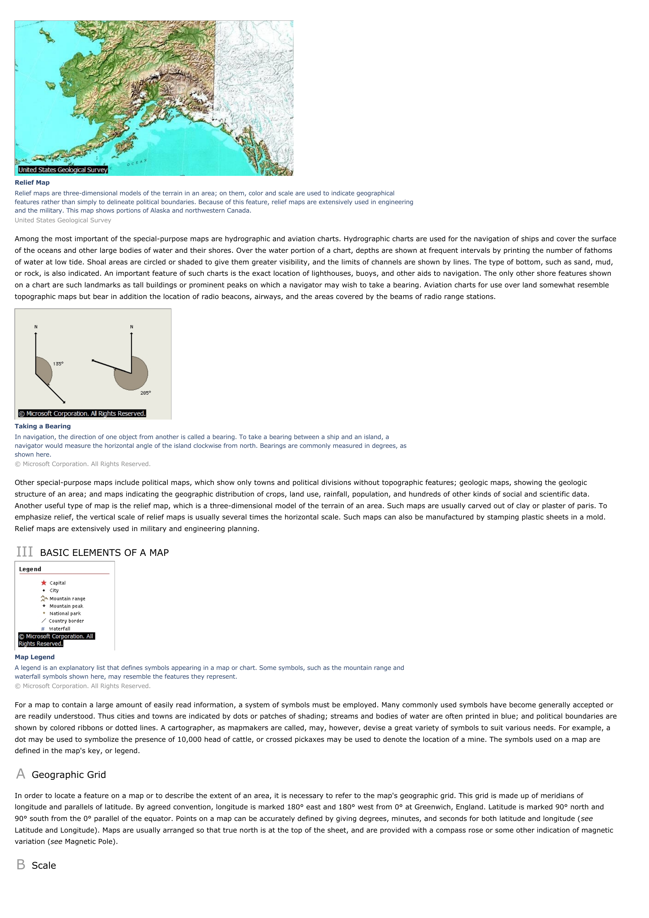
« Relief MapRelief maps are three-dimensional models of the terrain in an area; on them, color and scale are used to indicate geographicalfeatures rather than simply to delineate political boundaries.

Because of this feature, relief maps are extensively used in engineeringand the military.

This map shows portions of Alaska and northwestern Canada.United States Geological Survey Among the most important of the special-purpose maps are hydrographic and aviation charts.

Hydrographic charts are used for the navigation of ships and cover the surfaceof the oceans and other large bodies of water and their shores.

Over the water portion of a chart, depths are shown at frequent intervals by printing the number of fathomsof water at low tide.

Shoal areas are circled or shaded to give them greater visibility, and the limits of channels are shown by lines.

The type of bottom, such as sand, mud,or rock, is also indicated.

An important feature of such charts is the exact location of lighthouses, buoys, and other aids to navigation.

The only other shore features shownon a chart are such landmarks as tall buildings or prominent peaks on which a navigator may wish to take a bearing.

Aviation charts for use over land somewhat resembletopographic maps but bear in addition the location of radio beacons, airways, and the areas covered by the beams of radio range stations. Taking a BearingIn navigation, the direction of one object from another is called a bearing.

To take a bearing between a ship and an island, anavigator would measure the horizontal angle of the island clockwise from north.

Bearings are commonly measured in degrees, asshown here.© Microsoft Corporation.

All Rights Reserved. Other special-purpose maps include political maps, which show only towns and political divisions without topographic features; geologic maps, showing the geologicstructure of an area; and maps indicating the geographic distribution of crops, land use, rainfall, population, and hundreds of other kinds of social and scientific data.Another useful type of map is the relief map, which is a three-dimensional model of the terrain of an area.

Such maps are usually carved out of clay or plaster of paris.

Toemphasize relief, the vertical scale of relief maps is usually several times the horizontal scale.

Such maps can also be manufactured by stamping plastic sheets in a mold.Relief maps are extensively used in military and engineering planning. III BASIC ELEMENTS OF A MAP Map LegendA legend is an explanatory list that defines symbols appearing in a map or chart.

Some symbols, such as the mountain range andwaterfall symbols shown here, may resemble the features they represent.© Microsoft Corporation.

All Rights Reserved. For a map to contain a large amount of easily read information, a system of symbols must be employed.

Many commonly used symbols have become generally accepted orare readily understood.

Thus cities and towns are indicated by dots or patches of shading; streams and bodies of water are often printed in blue; and political boundaries areshown by colored ribbons or dotted lines.

A cartographer, as mapmakers are called, may, however, devise a great variety of symbols to suit various needs.

For example, adot may be used to symbolize the presence of 10,000 head of cattle, or crossed pickaxes may be used to denote the location of a mine.

The symbols used on a map aredefined in the map's key, or legend. A Geographic Grid In order to locate a feature on a map or to describe the extent of an area, it is necessary to refer to the map's geographic grid.

This grid is made up of meridians oflongitude and parallels of latitude.

By agreed convention, longitude is marked 180° east and 180° west from 0° at Greenwich, England.

Latitude is marked 90° north and90° south from the 0° parallel of the equator.

Points on a map can be accurately defined by giving degrees, minutes, and seconds for both latitude and longitude ( see Latitude and Longitude).

Maps are usually arranged so that true north is at the top of the sheet, and are provided with a compass rose or some other indication of magneticvariation ( see Magnetic Pole). B Scale. »

↓↓↓ APERÇU DU DOCUMENT ↓↓↓

Liens utiles