Panama Canal - geography.
Publié le 26/05/2013

Extrait du document


«
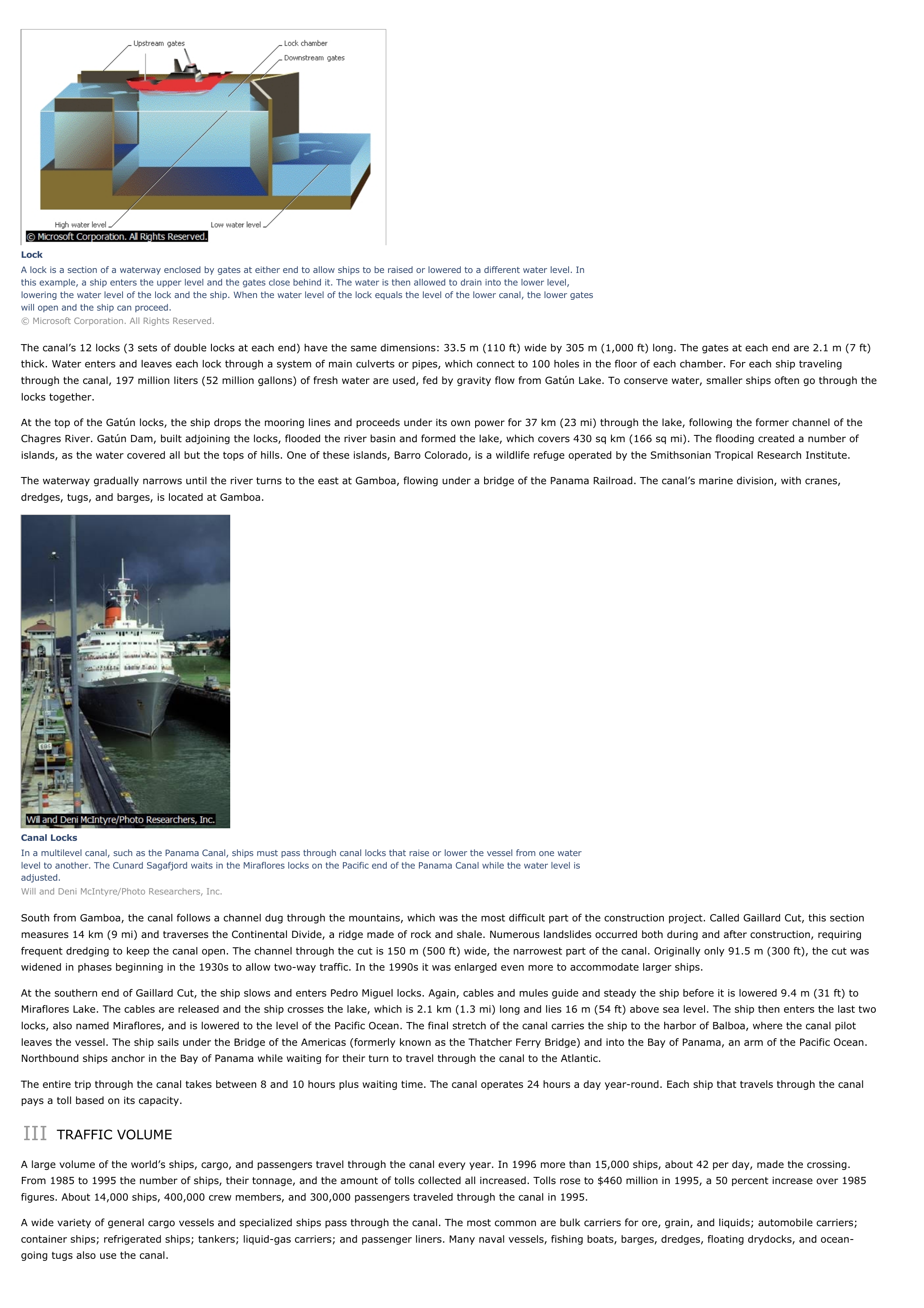
LockA lock is a section of a waterway enclosed by gates at either end to allow ships to be raised or lowered to a different water level.
Inthis example, a ship enters the upper level and the gates close behind it.
The water is then allowed to drain into the lower level,lowering the water level of the lock and the ship.
When the water level of the lock equals the level of the lower canal, the lower gateswill open and the ship can proceed.© Microsoft Corporation.
All Rights Reserved.
The canal’s 12 locks (3 sets of double locks at each end) have the same dimensions: 33.5 m (110 ft) wide by 305 m (1,000 ft) long.
The gates at each end are 2.1 m (7 ft)thick.
Water enters and leaves each lock through a system of main culverts or pipes, which connect to 100 holes in the floor of each chamber.
For each ship travelingthrough the canal, 197 million liters (52 million gallons) of fresh water are used, fed by gravity flow from Gatún Lake.
To conserve water, smaller ships often go through thelocks together.
At the top of the Gatún locks, the ship drops the mooring lines and proceeds under its own power for 37 km (23 mi) through the lake, following the former channel of theChagres River.
Gatún Dam, built adjoining the locks, flooded the river basin and formed the lake, which covers 430 sq km (166 sq mi).
The flooding created a number ofislands, as the water covered all but the tops of hills.
One of these islands, Barro Colorado, is a wildlife refuge operated by the Smithsonian Tropical Research Institute.
The waterway gradually narrows until the river turns to the east at Gamboa, flowing under a bridge of the Panama Railroad.
The canal’s marine division, with cranes,dredges, tugs, and barges, is located at Gamboa.
Canal LocksIn a multilevel canal, such as the Panama Canal, ships must pass through canal locks that raise or lower the vessel from one waterlevel to another.
The Cunard Sagafjord waits in the Miraflores locks on the Pacific end of the Panama Canal while the water level isadjusted.Will and Deni McIntyre/Photo Researchers, Inc.
South from Gamboa, the canal follows a channel dug through the mountains, which was the most difficult part of the construction project.
Called Gaillard Cut, this sectionmeasures 14 km (9 mi) and traverses the Continental Divide, a ridge made of rock and shale.
Numerous landslides occurred both during and after construction, requiringfrequent dredging to keep the canal open.
The channel through the cut is 150 m (500 ft) wide, the narrowest part of the canal.
Originally only 91.5 m (300 ft), the cut waswidened in phases beginning in the 1930s to allow two-way traffic.
In the 1990s it was enlarged even more to accommodate larger ships.
At the southern end of Gaillard Cut, the ship slows and enters Pedro Miguel locks.
Again, cables and mules guide and steady the ship before it is lowered 9.4 m (31 ft) toMiraflores Lake.
The cables are released and the ship crosses the lake, which is 2.1 km (1.3 mi) long and lies 16 m (54 ft) above sea level.
The ship then enters the last twolocks, also named Miraflores, and is lowered to the level of the Pacific Ocean.
The final stretch of the canal carries the ship to the harbor of Balboa, where the canal pilotleaves the vessel.
The ship sails under the Bridge of the Americas (formerly known as the Thatcher Ferry Bridge) and into the Bay of Panama, an arm of the Pacific Ocean.Northbound ships anchor in the Bay of Panama while waiting for their turn to travel through the canal to the Atlantic.
The entire trip through the canal takes between 8 and 10 hours plus waiting time.
The canal operates 24 hours a day year-round.
Each ship that travels through the canalpays a toll based on its capacity.
III TRAFFIC VOLUME
A large volume of the world’s ships, cargo, and passengers travel through the canal every year.
In 1996 more than 15,000 ships, about 42 per day, made the crossing.From 1985 to 1995 the number of ships, their tonnage, and the amount of tolls collected all increased.
Tolls rose to $460 million in 1995, a 50 percent increase over 1985figures.
About 14,000 ships, 400,000 crew members, and 300,000 passengers traveled through the canal in 1995.
A wide variety of general cargo vessels and specialized ships pass through the canal.
The most common are bulk carriers for ore, grain, and liquids; automobile carriers;container ships; refrigerated ships; tankers; liquid-gas carriers; and passenger liners.
Many naval vessels, fishing boats, barges, dredges, floating drydocks, and ocean-going tugs also use the canal..
»
↓↓↓ APERÇU DU DOCUMENT ↓↓↓
Liens utiles
- Panama Canal - Geography.
- Le canal de Panama
- Le canal de Panama
- Ouverture du canal de Panama
- Grand oral du bac : Le canal de Panama: Un travail de Titan aux multiples rebondissements


